
There is a total of 8 National Parks, The Kornati , The Plitvicka jezera, The Krka, The Paklenica, The Mljet, The Risnjak, The Brijuni, Northern Velebit .
Kornatski otoci (Kornati Islands), is a group of about 130 islands, islets and reefs sprinkled in the deep blue sea of the Adriatic covering an area of about 64 sq km. The Kornati archipelago is in Dalmatia, a coastal region of Croatia just across the cities of Zadar and Sibenik. The largest island is Kornat from which the archipelago takes its name. Other larger islands are, Piskara, Kurba, Vela, Zut, Sit and Levrnaka. Apart from a tiny area of cultivated land with fig trees, olives and vineyards, Kornati islands are rocky, covered with thin grass, rare trees and Mediterranean scrubs. Over the time erosion has been caused by the sea, over grazing by sheep and fire.This erosion has deprived the islands of their primeval luxurious vegetation, and the people have moved to more hospitable islands. Some of the bigger islands were inhabited during the Neolithic age by Illyrians. A number of wealthy families from Zadar and later Venice have claimed possession of the larger islands. The Kornati have no permanent inhabitants, although the present owners from nearby larger Dalmatian islands periodically visit Kornati to tend their vineyards and olive groves, bringing their sheep to graze. The sea around the islands is rich with fish and a variety of marine life....
The islands have no spring water, only rainwater collected in waterholes. The unique feature of the islands lies in their rugged shores with many caves and coves. The landscape of chalk limestone is covered with bushes of rosemary, juniper, lavender, thyme, myrtle and sage. Pathways leading to steep and huge cliffs facing the open sea and others gently decline towards the sea, ending in a small bay with a jetty and one or two fishermen's cottages surrounded by pine, olives and fig trees....
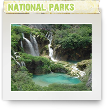
Plitvicka jezera (Plitivice Lakes) is Croatia's well known national park. Plitvice Lakes are also listed in UNESCO's Register of World Natural Heritage. Plitvice Lakes is a group of sixteen small lakes - Proscansko Jezero, Labudanovac Lake , Ciganovac Lake , Galovac Lake, Kozjak Lake... - mutually conected with numerous large and smaller waterfalls. Plitvice waterfalls are created by deposition of travertine -a kind of limestone that created this unique and attractive wonder of nature.
Plitvice National Park is the area surrounded by dense forests of beech, fir and spruce, watered by varous springs of the Korana River.
Plitvice National Park is decorated with several caves and flower meadows too. Brown bear found , among other animal species, their home in Plitvica Lakes too.
Area of Plitvice Lakes is paradise for walkers and hikers as well as nature lovers. Lakes are lovely and cool in summer, icy and calm in winter, yellow and ocre in autumn, green and fresh in spring - any time of the year it is a priviledge to be around those lakes!
Plitvice Park is conveniently located near the main road that connects Zagreb and Croatia Adriatic Coast. It is easily accessible by public transport as well as by bicycle, from Karlovac, Zagreb or Split. Due to it's popularity among Croatian as well as other visitors, there are various accommodations available in and around Plitvice Lakes.
Krka, The Sibenik region is one of the Mediterranean’s quieter corners where there is still the space and time to make discoveries in a fascinating and varied landscape.
The Krka National Park and the town of Sibenik are symbolic of the contrasts that are found in central Dalmatia. There are the rugged limestone mountains of the mainland set against the intricate archipelagos of the Adriatic Sea. And there is the diversity and natural beauty of the various parks and reserves in combination with the rich and well-preserved cultural heritage of the ancient coastal settlements. It is a landscape that offers much to the interested visitor and which, thankfully, remains free from the concrete development of resorts. Mediterranean summers: Sibenik and the central Dalmatian coast enjoy a pleasant Mediterranean climate with warm, dry summers coupled with cooling sea breezes and the temptations of the Adriatic. Inland, in the national park, the river and the waterfalls counteract the heat. In winter it is mild and wet, but note that much is likely to be closed.
Karst landscapes: Krka National Park shows the Croatian karst at its best. Karst environments are formed by the dissolving action of carbon dioxide and water on carbonate rock, which in Krka’s case is limestone. Over thousands of years this process has resulted in the formation of a series of distinctive geomorphological features, with the Krka river fighting its way through a long gorge and plunging over rapids. Karst landscapes also feature highly developed subterranean drainage systems, making them ideal territory for those interested in exploring potholes and caves.
The area is rich in Mediterranean and sub-Mediterranean flora and fauna. The surrounding forest is mixed, with hornbeam, cypress, poplar, oak and willow represented, while over 200 bird species are found, including golden eagles, and the river is home to Visovac trout and Adriatic salmon.
The Adriatic is also the Mediterranean at its best. Elsewhere polluted and crowded, in Croatia the sea is blue and clear and clean. It also provides the rhythm of life on the coast, with time being marked in the small fishing villages with the departure and safe return of the boats.
Krka National Park: Established in 1985, the 142 sq km Krka National Park follows the line of the Krka river, from its source in the foothills of the Dinaric mountains on its short journey through the dramatic karst landscape to its finish in the Adriatic. The river flows through a limestone gorge, dropping over 220m in 50km, with eight sets of rapids. Only two falls – Skradinski buk and Roski slap – are in the park itself, although the former is the most impressive of all with a 46m drop over seventeen limestone steps.
Paklenica, is Croatian National park that cover the most attractive parts of southern Velebit , as well as its highest peaks.The main attraction of the Paklenica Park are two impressive canyons of Velika and Mala Paklenica, vertically cut into the mountain from the sea to the Velebit's highest peaks.
In this small area of the national park, there are several unusual carst forms, caves, and varied flora and fauna. There are various species of large mammals in the park. too. Throughout the park, one can see game species such as roe deer , red deer , chamois and wild boar. Large predator species include the brown bear, the wolf and the lynx - though there are not a lot of visitors who can claim seeing them.
Anica kuk - the steep rocks in Paklenica Park ( see right photo) is popular spot for hikers and climbers. In the upper parts of the canyon there is a large woodland area.
Due to it's unique geographical position ( similar as Biokovo Mountain) Paklenica National Park features several vegetation and climate zones - from warm Mediterranean to cold mountain climate. Velebit is a branch of Dinaric Alps structure, mountain chain that stretches from Slovenia, through Croatia, Bosnia and Herzegovina via Montenegro to Albania. Velebit Mountain, as well as Biokovo is the only part of Dinaric Alps that gets so close to the sea.National Park Paklenica is listed as Croatian national park in 1949.
The Island of Mljet is situated couple of hours boat ride east from Island of Korcula towards Dubrovnik.
A national park MLJET includes a western part of this green and tranquil island of the Adriatic Coast. The Park is characterized by two deep bays which are called lakes due to their narrow passages to the open sea (Veliko and Malo jezero/ the Great Lake and the Small Lake). Both lakes are surrounded by dense Mediterranean vegetation. There is a tiny island in one of the lakes, called Melita ( Mljet) , with 12th century Benedictine monastery. There are a lot of legend connected with this island - one of them is that Mljet was holiday destination of greek hero Ulysses!
The National Park Mljet was established in early sixties of last century. It covers about 30 square kilometers of area on the western bit of Island MLJET , which is about 1/3 of the Island. It consist of two natural salt lakes ( Veliko and Malo jezero) that are interconnected by a narrow channel. Veliko jezero ( Large Lake) covers the area of 1,5 square kilometers. Malo Jezero (Small Lake) is about 1/4 of square kilometers. The salinity of the water in the lakes is bit lower than in the sea, due to intake of fresh waters. The temperature of the Lakes is usually higher then open sea temperatures for about 4 degrees centigrade. Due to these details, Veliko and Malo Jezero are popular places for visitors to swim in. Both lakes are surrounded with dense old pine forest. In the middle of Veliko Jezero there is a little island called Melita ( above photo ) where Benedictine monastery is located.
Walking and cycling are allowed all around National Park Mljet. Some parts of the Nationa Park can be reached by car too. National Park Mljet offers a lot of silence and numerous islolated spots to be enjoyed.
Risnjak, is a forested mountain massive not far from the city of Rijeka, named after lynx (ris in Croatian), its best known inhabitant. The National Park of the same name stretches from 300 to 1,500 m above the sea level. Due to its position at the junction between the Alps and the Dinarides, and from the Mediterranean to Pannonia, almost all types of forests, as well as many plant and animal species are gathered here, in a relatively small area. The beauty of the forest, carst phenomena, beautiful springs and magnificent views attract many hikers and other nature lovers to Risnjak.
Brijuni, Brijuni archipelago are attractive group of islands near Istria Peninsula, with the main islands Veli Brijun that is Croatia National Park and open to visitors. The fact that it was visited by the élite of Austrian, Hungarian and German aristocracy when Istria was part of the Austro-Hungarian monarchy speaks of its beauty and charm. In more recent history almost every major statesman visited the islands as Brijuni were residence of late President Tito of Yougoslavia.
The islands are rich in natural beauties, flora and fauna brought here from various parts of the world. On Brijuni there is an attractive archaeological site the Byzantine castrum and luxurious Roman villa, Ethnographic collection, Collection of frescoes, Archaeological Museum and Natural history exhibit.
The Brijuni archipelago is separated from the mainland by the two-miles-wide Fažana Channel to the northwest of Pula. The archipelago stretches over 736 hectares and forms a 30 miles long coast. It is a place where sumptuous wildlife (680 different local and exotic plants, 150 bird species, etc.) couples with a wealth of historical traces ranging from a Neolithic settlement and Illyrian ruins, to monuments dating from the Byzantine period and the Middle Ages, as well as from Austro-Hungarian architecture to a more recent time.
Brijuni Minor fortress, built in the late 19th century is the largest edifice in the defence system of the Austro-Hungarian central naval base of Pula. Stretching over 15.750 square meters, the edifice is 175 meters long and 90 meters large.
The “Brijuni” National Park also includes three-star hotels (“Neptun”, “Istra” and “Karmen”) with 226 beds, and luxurious villas with 31 beds.
The archipelago of Brijuni is an extraordinary blend of natural, historical and cultural heritage. The mild climate and the favourable geographical conditions, deep retracted bays and easily defendable elevated fortifications, have secured a continuum in the human activity on the island from a pre-historic age until the present day.
North Velebit- Velebit is an untamed mountainous ridge which looms as large in the Croatian mentality as it does on the ground. Lying adjacent to the Adriatic and occupying over 2,000 sq km in a belt 145km long and up to 30km wide, this limestone mass is a designated UNESCO biosphere reserve. Velebit is perfect for those wanting to explore a fascinating area in solitude. It is possible to hike the whole length of the ridge, following Premuzic’s path and staying in mountain huts, whilst the more compact Paklenica National Park also offers excellent walking opportunities.
On the ridge
Despite its proximity to the coast and the pleasant climate of nearby island archipelagos, Velebit’s size ensures that only on the coastal slopes is it typically Mediterranean. On the top of the ridge the climate is consistently continental, with intense summers exacerbated by the scarcity of surface water and then followed by cold, harsh winters. The peaks of Velebit endure temperatures below 0°C on 160 days in a year. July to September are thus the best months to visit.
Velebit combines sheer size with the jagged intricacies of karst landforms. From afar it has an impressive bulk, with the ridge being untouched by any major transverse passes. On both sides steep slopes sweep downwards, to sea level at the coast and inland to the Lika plateau. Thus, Velebit stands isolated and aloof as a long barrier separating the sea from the interior. The ridge’s limestone has been weathered over thousands of years to create a landscape of deep gorges, sheer cliffs, dark sinkholes, caves and subterranean drainage systems.
As with the climate, the flora of Velebit varies with altitude and location. The coastal slopes are rocky, with a thin covering of maquis and scrub. Inland there is considerably more variety, with broad, leafy woods developing into denser, wilder beech, juniper and pine forests towards the peaks. Just below the ridge, the flora becomes sub-alpine with meadows filled with wildflowers. Bears are the most famous residents of the reserve, but wolves, martens, wildcats, deer, snakes, golden eagles, griffon vultures and long-eared owls can also be found.