
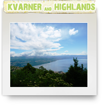
The Kvarner Gulf (Croatian: Kvarnerski zaljev, Italian: Golfo del Quarnero/Quarnaro/Carnaro; sometimes also Kvarner Bay) is a bay in the northern Adriatic Sea, located between the Istrian peninsula and the northern Croatian seacoast.
The main islands within the Kvarner are Cres, Krk, Pag, Rab and Lošinj. The main portion of the Kvarner bay is that between the mainland, Cres and Krk. A smaller body of water located between Cres, Krk, Rab and Pag is called Kvarnerić (the little Kvarner).
Rijeka | Opatija | Icici | Lovran | Mošćenićka Draga | Kastav | Crikvenica | Bribir | Dramalj | Kraljevica | Jadranovo | Selce | Novi Vinodolski | Senj | Jablanac | Karlobag
The economic and administrative center of this popular and busy island region is Rijeka, Croatia’s largest port.
Other than Trsat Castle, built on a hilltop commanding splendid views out to sea, Rijeka has little of architectural interest, its main claim to fame being the exuberant celebrations it puts on each year in February for Carnival.
The main tourist centers of the Kvarner region are Opatija, Crikvenica and Novi Vinodolski (sometimes referred to as the ‘three rivieras’), all of which have extensive pebble beaches complemented by good accommodation and recreational facilities. Opatija, Croatia’s oldest tourist resort, was popular with the Austro-Hungarian nobility and some of its former fin-de-siecle elegance remains.
Of the many islands scattered throughout the Kvarner Bay, Krk, connected to the mainland by a road bridge, is the most developed as well as the largest, with clean beaches and extensive tourist facilities. Further out lie Rab, home to the delightful medieval Rab Town with a number of elegant Romanesque bell towers; Cres, which contains the Vransko Lake and is popular with nature lovers; and Losinj, which has pine woods and numerous bays with beaches. Inland from Rijeka, the Risnjak National Park is located in the mountains of Gorski Kotar and rises to 1528m (510ft) above sea level, making it a popular destination for hiking and climbing.
The town of Rijeka is an important business, trade, industrial and cultural centre in the western part of the Republic of Croatia. It is the number 3 biggest city in Croatia and has about 200.000 inhabitants.
It is located on the Adriatic, at a point where the sea has made its deepest incision into the European continent. Due to its natural and geo-political characteristics the area is ideally situated for harbour and shipping centre development. In addition to activities related to the sea, such as tourism, shipping industries, forwarding agencies, harbour activities and shipbuilding, Rijeka within its wide boundaries also boasts numerous other major industries; civil- mechanical- electro- engineering, oil and petro-chemical, timber, pulp and paper industries all feature in Rijeka's business portfolio.
However, the largest part of economy is concentrated, apart from tourism, on export. There are business and trade connections with more than 80 countries throughout the world.
Rijeka began to evolve during the 13th century, however, the most significant development was from 1728 onwards, when the Caroline road towards Zagreb was built, and the construction of a railway link was completed. Being connected with the entire central Europe via Zagreb, Rijeka has become one of the leading harbours on the Mediterranean sea.
The port of Rijeka has a long maritime history and has been utilized as a cargo transit port since ancient times, linking middle Europe with numerous countries throughout the world. The annual turnover is some 20 million tons of miscellaneous cargo.
The harbour has good communications with the hinterland and substantial working and warehousing capacity in the area of more than 1 500 000 m2, furnished with modern transport facilities.
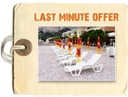
Kvarner bay and Istrian riviera, with more than 50% of the entire tourist capacity of Croatia, represent the most developed parts of the country as far as tourism is concerned. This region has a long tradition in tourism, dating back to the 19th century. Its specific geo-topographical position ensures a very pleasant climate with hot summers and mild winters. The average annual temperature is some 14°C and the region enjoys more than 2100 hours of sunshine. The mild climate, beautiful scenery and hospitality contribute to the attractiveness of the region.
The extremely rugged coastline with numerous gentle bays is perfect for swimming and other aquatic activities. Naturally, there is a great demand for nautical tourism. In Kvarner, the Istrian Riviera and the associated islands there are some 16 marinas and numerous small ports with a total mooring area of 500 670 m2 being available. The capacity of the marinas alone is 4 800 aquatic moorings with a further 1700 dry docks.
Furthermore, facilities are accompanied and refreshed by cultural and social events such as concerts, music festivals, sports competitions, beauty contests and folk festivities comprising local folklore and specific gastronomic delights.
Activities
Being a coastal town Rijeka boasts a wide diversity of sporting activities. Aquatic sports include sailing regattas, internationally renown spear fishing contests, sub-aqua sea fishing competitions, swimming and water polo. 30 km from Rijeka the mountains offer opportunities for the hiking, mountaineering, hunting and coarse game fishing enthusiasts.
During the winter months the mountains are covered with snow and provide suitable slopes for the amateur and professional skier alike. The town itself has two professional football teams and numerous other sporting clubs; basketball, hockey, handball, tennis, badminton and the local version of bowling.
Opatija , port and tourist center at the foot of Ucka Mountain. It lies on Istria’s eastern coast in the Bay of Kvarner, 13 km southwest of Rijeka. It has the longest tourist tradition on the eastern coast of the Adriatic. In 1844 the first villa for tourist purposes was built. The Croatian ban Josip Jelacic and Austria’s Empress Maria Ana visited Opatija in the past. Kvarner, the first hotel on the Adriatic, was opened in Opatija. It was proclaimed the first climate resort. After hotel Opatija was built, the town became an elite destination. The economy is based on tourism. The town has evergreen vegetation, as well as exotic plants around some of the villas. The tourist offer includes all types of accommodation. Opatija has luxurious villas and hotels. Guests have at their disposal various restaurants, numerous sports and recreational facilities, as well as cultural and entertainment events.
Additional facilities:
Those interested in diving course can register with the diving club Mali Raj. Organized cycling tours are also available. The hotels Ambasador, Millenium, Imperial, Grand Hotel Adriatic, Grand Hotel Kvarner Amalia, Admiral and Grand Hotel Palace-Bellevue have congress centers of different capacities. Larger boats can dock in the outer part of the port, while smaller boats can dock in the inner part. By hotel Admiral lies the marina of the same name, open throughout the whole year. The most famous cultural and entertainment events are carnival festivities in January and February, the international sailing regatta in May, as well as the Opatija Sailing Cup in November.
We recommend:
Sightseeing of sv. Jakov church with elements from the 16th century, parish church Navjestenje Blazene Djevice Marije built in the fiorentina quattrocenta style and Villa Angiolina built in the style of Classicism, surrounded by exotic plants from China, Japan, Australia and South America. Walks along the Lungomare Promenade that stretches from Volosko to Lovran or along Zora Promenade, built in the 19th century.
Icici
Basic information
Tourist destination on Istria’s eastern coast, 7 km south of Opatija, placed in the Bay of Kvarner at the foot of Ucka Mountain. Its tourist tradition goes back 150 years. Thanks to the mild climate and rich vegetation, the tourist season lasts all year long. Accommodation is available in the hotel, apartments and camping site. The sports and recreational offer consists of tennis courts and water sports equipment rental. Nautical tourism is developed and the well-known ACI Marina Opatija offers 400 berths and 100 dry docking spaces for vessels from 5 to 13 meters long.
Additional facilities:
Besides for walks, the promenades in Icici are also suitable for bike riding, jogging or roller blading. Ucka Mountain is a special challenge for mountain climbers. The cultural and entertainment offer includes festivals and other events held in Opatija and Lovran. Those interested in nightlife can visit the disco club Paladium, the night club Adriatic and the casino Rosalio.
We recommend:
Lungomare Promenade that connects Opatija and Lovran via Icici is ideal for jogging, bike riding and roller blading. Trips to Plominska staza trail that connects the places of Poljane, Veprinac and Ucka, at the height of 1396 m. It offers a splendid view of the Bay of Kvarner.
Lovran, is a town and summer resort on the south-eastern coast of Istria, 5 km south of Opatija. Chief occupation is tourism. Lovran offers a variety of accommodations (hotels, villas, rooms, apartments), sports and recreational facilities. Water sports offer is particularly interesting (yachting, water skiing); angling, walking along the promenade (Lungomare).
Numerous hotels and private houses designated for winter vacation and holidays have been constructed around the old coastal part of Lovran and along the road to Rijeka. Thus, Lovran represents, together with Opatija, the centre of the Liburnian riviera, with landscaped parks and gardens. Farms have been redesigned for tourist purposes, with viniculture, fruit and vegetable growing being the predominant occupations
Lovran is a significant tourism destination and began to develop at virtually the same time as Opatija. Lovran has exclusive and renovated villas dating back to the Austro-Hungarian monarchy, such as the Villas Frapart, Astra, Eugenija, Magnolija and Blankenstein. In this exceptional crossing of past and present, and the coming together of the sea and mountains, the inland region behind Lovran is also developing. Here, rural tourism is nurtured, based on delicious autochthonous products such as chestnuts, asparagus and cherries. With the two city beaches Peharovo and Kvarner, there are a number of smaller beaches and sun tanning areas, and the well known Orthopedic Clinic is situated in Lovran, reminding us of the tradition of health care tourism.
Moscenicka Draga is a town and harbour on the eastern coast of Istria, in the Rijeka Bay. Moscenica draga has a little population of 472. The harbour is exposed to all winds, apart from those from the fourth quadrant. Yachts can anchor along the embankment, however anchoring is dangerous during bad weather. In the inner small harbour only small vessels can anchor. During the summer, yachts can anchor around 100 m off the shore. Moscenicka Draga has a harbour master's office. The climate is favourable; the average air temperature in January is 5.8 °C, and in July 23.3 °C. Situated on the main road (M2, E751).
Moscenice and Moscenicka Draga are connected by the asphalt road or, for those in good shape, by 753 steps which begin at the foot of the hill, on the beach of Sveti Ivan.
Tourism first emerged at the beginning of the 20th century, to become today the chief occupation of the town and its surroundings. Moscenicka Draga has a variety of accommodation facilities (hotels, rooms, apartments), a popular 2-km long pebble beach, sports and recreational facilities. Yachting regatta represents another attraction. The nearby Opatija offers entertainment of all kind. A walking path runs through Vojvodici, Detani and Trebisce to the village of Ucka (995 m), from which one can reach the summit of Mt. Ucka (1,396 m).
Kastav
The little town Kastav is situated 11 km northwest of Rijeka. Built on a isolated hill 378 m over the sea surface dominates over a wide territory old trails conducing from Triest and Slovenia to the port of Rijeka.
Ancient prehistoric building determines the location (near to Misinci necropolis) and antiquity determines the itinerary (the road Tarsatica-Tergeste) and the Middle Age originated the urban genesis in the walls with towers and the urban gate - all this yet in a good condition. The ground-plan and architectonic objects of Kastav show the disposition of urban agglomerations fortified with a solid system having nine towers, describes by the author Valvasor in the 17th century.
Situation and construction of the town is oriented towards the eastern and southern declines of the hill where the houses were built in horizontal rows, narrower to the northwestern rim where a threenaval big basilica of St.Helene dominates with a belltower vertically this densely packed agglomeration.
Crikvenica is situated in the Kvarner bay at the Adriatic sea, at a distance of 35 kilometers from Rijeka, a big road and railway junction and the centre of the district of Primorje and Gorski Kotar, a part of which is also the town of Crikvenica. The whole town of Crikvenica is in fact a riviera with a row of almost connected small tourist resorts: Selce, Crikvenica, Dramalj and Jadranovo. The town spreads on about 28 square kilometers in the coastal zone, which is about 15 km long and about 2 km wide, and is squeezed between the sea and the elongated littoral reef of an average height above sea level of about 300 m. The neighbourhood of the airport on the island of Krk, the passenger and the cargo sea ports in Rijeka, as well as a good road and railway connection with Middle Europe contributed to an early development of tourism which has in the region of the present Riviera of Crikvenica a tradition of more than one hundred years.
Due to the favourable position of Crikvenica and its being sheltered from strong winds - from the north thanks to the slopes of the mountain of Kapela and from the south thanks to the island of Krk-its climate is mild and relaxing. The characteristics of the climate of this region are dry, fair and pleasantly warm summers and mild winters with a healthy local system of winds. The amplitude between the average annual temperature maximum and minimum is small. The centenary average of temperature is 14.2°C, and the average summer temperature is 23.6°C. Snow, fog and a temperature below 5°C are very rare. The temperature of the sea reaches in summer not more than 27°C. The sea air distinguishes itself by purity and by dispersed desirable oligo minerals and there are no noxious pollen allergens or waste gases.
Bribir is a nice village in the Vinodol valley, located on Glavica hill, 6 km northeast of Novi Vinodolski. This historical little town, located in a picturesque landscape, is visited by numerous lovers of antiquities. In its surroundings is an interesting forested area (700-900 m) with summer cottages, as well as several resorts offering specialities of the national cuisine.
Bribir is built on a hill above the fertile valley of Vinodol. It is one of important towns of the principality of Vinodol, and it was its administrative and ecclesiastical centre in the Middle Ages. The Bribir district was composed of the Town and 14 hamlets. In the Middle Ages it is enclosed in walls and towers, which are almost completely demolished in the course of the 19th ct. The Tower Only the Northeast part of the wall and a square tower have survived of the strong wall of fortress. A fortified feudal citadel was situated inside the fortified settlement on the northern side. It was demolished to a great extent at the end of the 19th ct. In the 13th ct. the town is in possession of the Frankopans, when it partakes in the bringing in of the Law of Vinodol. Afterwards it comes under the counts of Celje and after that it is a regal town of Matija Korvin, and subsequently is kept by the family of Zrinskis until 1671. and the execution of Petar Zrinski in Bečko Novo Mesto (Wiener Neustadt) .
Dramalj
Place on the coast, in the Vinodolski Channel, 3 km northeast of Crikvenica. It is characterized by nice sandy beaches suitable for small children, therefore, for family holidays. Besides a pleasant holiday, Dramalj offers guests various recreational possibilities such as walks, roller blading, jogging and bike riding. You can take the coastal promenade to nearby Crikvenica. Accommodation is available in hotels, apartments, rooms and in a camping site. The Kacjak Peninsula is especially attractive for tourists. The swimming area and additional sports and recreational facilities enable a pleasant active holiday.
We recommend: Visits to the nearby towns of Crikvenica, Novi Vinodolski and Selce. Excursions to the national parks Risnjak and Plitvice Lakes, as well as to the Gorski kotar region. Tour of the Biserujka Cave by Silo on the island of Krk.
Kraljevica, which is located between Rijeka and Crikvenica, thirty kilometers from Opatija at the entrance to the bridge for the island of Krk. Kraljevica is a city that was mentioned as early as the 13th century. Today, in addition to the oldest shipyard on the Adriatic, Kraljevica is dominated by two medieval castles and the church of the Croatian nobles Zrinski and Frankopan. The town has all the necessary food shops, a small open market with a fish stand, pharmacy, medical center, post office, currency exchange bureau, tourist bureau, restaurants and cafés.
In the Kraljevica harbor and the nearby harbor of Čri¨njevo, mooring and vessel-lifting services are available.
After the highway is completed, Kraljevica will be a ninety minute drive from Zagreb. It is exceptionally attractive to guests who, in addition to exceptional quiet and privacy in the garden or beach and the comfortable apartment accommodations, want to take excursions to nearby destinations: Fu¸ine and other attractive places in Gorski Kotar, Opatija, the island of Krk, a ferry to Cres and Lo¨inj, or even a day trip to the Plitvice Lakes. In Kraljevica, an excursion boat provides half-day and day excursions to surrounding islands.
In addition, the SELCE Hot Springs (Terme Selce) are in the vicinity, where Janica and Ivica Kostelić often go to recuperate, providing various medical services and physical therapy.
Jadranovo is a town, harbourand seaside resort on the coast of Mala Vrata (Small Gate) in Tihi Kanal (Still Channel), between Kraljevica and Crikvenica, opposite of the northernmost part of the island of Krk, which is the closest to the mainland.
The coast is, especially in the north-western part, covered with sub-Mediterranean underbrush. In enclosed places and fences there are olive trees. Chief occupations are farming, fishing and tourism. The most spacious shore (Havisce cove) houses a bungalow complex.
A pine forest and numerous small beaches make Jadranovo an attractive tourist destination. The most spacious shore, the cove of Havisce, houses a complex of vacation homes. Visitor opportunities include various water sports, walking trails (Lungomare) and entertainment and cultural programs in nearby Crikvenica. The traditional event called Days of Jadranovo - Jakovlje, with cultural, entertainment and sports programs are held in the week 21st-27th of July.
Selce, town and port in Vinodolski Channel, 3 km southeast of Crikvenica. The area has a rocky shoreline, as well as pebble and sandy beaches. The economy is based on agriculture, wine and olive growing, stockbreeding, fishing and tourism. Tourism started to develop some hundred years ago. In 1894, the first swimming area was opened. Accommodation is available in hotels, rooms and camping sites. The sports and recreational offer includes tennis courts, mini-golf, various water sports, while the promenade that connects the town with Crikvenica is suitable for bike riding, jogging and roller blading. The most attractive cultural and entertainment events are Fishermen's Evenings, whereas nearby Crikvenica offers various types of entertainment. Selce is an attractive destination for an active family holiday.
Additional facilities:
Those interested in diving courses can visit the diving club Mihuric
We recommend:
Sightseeing of the cultural and historic sites, especially sv. Katarina church from the Classicist period. Excursions to the neighboring towns of Crikvenica and Novi Vinodolski.
Novi Vinodolski is a town and harbour in the region of the Croatian Primorje, at the estuary of the river Suha Ricina in the Vinodol Channel. Novi Vinodolski has a population of 3,851. Situated in the south-eastern part of the Vinodol flysh vale stretching from the northwest to the southeast and reaching the sea at Novi Vinodolski. Up to 1953 the town was called Novi. It consists of an older, compact part on the hill and the more recent one along the sea, southeast of the port with a promenade, tourist facilities and many villas. During the last years many of new villas and weekend houses are being built, the town is expanding to the northwest of the port, below the main road. The port is exposed to the winds blowing from the fourth quadrant. Berths for yachts are found at the breakwater, at the part facing the coast, along the embankment and on both sides of the pier (depth 2.7 m). Chief occupations include farming, viniculture, fishing and tourism. There is a tourist resort Zagori not far from Novi Vinodolski. The town is located at the intersection of the main road (M2, E65) Rijeka - Zadar and the regional road to Ogulin
A picturesque town with a rich tradition in tourism. The first wooden public beach in Novi Vinodolski was constructed already in 1878. Novi, once famous for its public beaches, was awarded the royal award for nicely maintained beaches. In 1889 a municipal beach was constructed in Lisanj Cove. Raising the flag on the beach marked the swimming time (red for men, white for women). The first hotel, Lisanj, owned by the Potocnjak family and erected in 1892, was annexed at the beginning of the 20th century, and still stands there as a representative example of the hotel architecture in Croatia. The pleasant climate and adequate tourist offer enabled Novi Vinodolski already in 1906 to gain the official status of a seaside and climatic resort. The present offer comprises hotels, a tourist resort, campsites and numerous catering establishments situated near the sea with beautiful, maintained and easily accessible beaches. A variety of sports facilities, indoor and outdoor swimming pools with sea water as well as other catering and recreational facilities are located in the vicinity. Among cultural events, Novi Vino-dolski cherishes especially the winter carnival (January/February) and the Sts. Philip's and James's Day, patron saints of the town (May). Recently, due to its special engagement in tourist trade, Novi Vinodolski has become an international centre of the summer carnival which takes place in August.
Senj is a town and a port in the Velebit Channel and has a population of 5,998 inhabitants. Contemporary Senj, the ancient Senia, is the oldest town on the Croatian coast. More than 30 centuries have passed since its establishment. Being the shortest natural connection between the inland and the sea, Senia became a very important Northern Adriatic harbour and trading centre.
At that time, by its surface area and importance, the city was larger then today's Senj, the evidence of which are necropolises, epigraphic monuments and other antiquities.During the people's migration, Senia was devastated. At the beginning of the 7th century the immigrated Slavs built a new settlement upon the old city ruins. In the course of the 12th century Senj regains the former importance. Since 1526 the city had been ruled by Habsburgs. In the 16th century it became the resort for many immigrants, who ran away from the Ottoman danger and became Senj's Uskoks, fighting fiercely against Turks and Mletians for 80 years. In accordance with the Madrid Peace in 1617 Uskoks were moved out, their ships burnt down. In 1779 the Josephine road (Senj-Karlovac) was built. Senj is today the most important communication junction and transit station between Rijeka and Zadar.
Another name for Senj, it can freely be said, is Nehaj, after the name of the fortress built in 1558 by the Senj's captain Ivan Lenković. He raised it in order to keep more efficiently the city safe from the Turks and Mletians, using ruined churches and cloisters outside the city merged with it, e.g. "Senj's Glagolitic Stone Tablet", dating from the 11th century. The Sabac Tower from the 13th century is a part of the coastal fortifications. The Grand Gate was built in 1779, making the end of the Josephine road (Josephinea Finis). Senj's princes Frankopans built about 1330 the Citadel to strengthen the defense capabilities of Senj, serving as their residence as well.
Senj is well-known for its eventful history and for its past inhabitants' heroic deeds, but it is also one among the nurseries of Croatian culture.
As of the 10th c. Glagolitic (old Slavonic) script was used in Senj along with Croatian language. Hence, many both hand-written and printed Glagolitic sacral books, documents and tablets have survived from the period, the most significant being the Senj Glagolitic Tablet dating back to the end of the 11th c. In 1493., a Glagolitic printing house was established in Senj, being the second oldest in the country.
Senj has not only a glorious history, but also a fascinating present. While some of its sons were making their way to freedom with swords and rifles, others were paving the way to knowledge and enlightenment with pens in their hands. By doing so, they did a lot for their native town, as well as for the local history, turning Senj into the oldest cultural and national liberation centre of its people. Senj is native town of poets Mate¨a Kuhačević and Silvije Strahimir Kranjčevic, novelist Vjenceslav Novak, playwrights and theatre officials Julije Rorauer, Milan Ogrizovic and Milutin Cihlar Nehajev. Even today, there are about dozen masters of the written word still active in Senj. There are only few Croatian Adriatic towns which history has been preserved so well as it is the case with Senj.
The old part of the town is a living museum in itself, the Municipal Museum has several permanent exhibitions, the sacral heritage exhibition at the Rectory is always well attended, while the visit to Nehaj ("Fear Not" castle is absolutely unavoidable for all those who come to Senj. If we take into account its size, the town's cultural activity is still above average. For over 20 years now, Senj has been the centre of harmony-singing in the area (Croatian Littoral & Istria), while this year it will have been 30 years of Senj's carnival tradition i.e. of its Summer Carnival Festival (the first weekend in August), owing to which it has become a member of European Carnival Towns Association.
Jablanac a village in Croatia, located on the Adriatic Sea underneath the Velebit mountain, overlooking the island of Rab. The village has a ferry port that connects it to Rab. The population of Jablanac is 118 and it is located in the municipality of Senj (which lies to the north). The village has 1 hotel (Ablana), 1 harbour front cafe (Ruža), 1 harbour front restaurant (Lux) and a street cafe/diner (Oaza). There is 1 small supermarket (Porat) and a Harbourmaster's office. The village also boasts the lowest mountaineering hut in the whole of Europe which, at 20m above sea level, overlooks the ferry. There is a newspaper kiosk and common currencies can be exchanged next to the ferry ticket office. Avoid visiting the village on a Saturday during the summer and on public holidays as the queues for the ferry can stretch for up to 4km back up to the main coast road.
Local attractions include Zavratnica inlet where you can see a sunken military ferry wreck from WW2 and stunning scenery. Nereby is the Velebit mountain and the beautiful National park "Sjeverni Velebit".
Karlobag is a small town on the Adriatic coast in Croatia, located underneath Velebit overlooking the island of Pag, west of Gospić and south of Senj. The Gacka river also runs through the area. The population of the municipality is 1,019, with Croatians making up the majority at 92.44%, and with 510 people living in Karlobag itself (census 2001).
The town was founded by the Holy Roman Emperor Charles IV, Holy Roman Emperor in the 14th century, and is thus named after him (Karlo being the Croatian variant of Charles.) The town itself has several historical landmarks, especially the Capuchine Monastery, which is full of old paintings, and other churches, most dating back to the 17th and 18th centuries. On the hill above town are the ruins of a Middle Age fortress called Fortica, and the church of Saint Charles of Borromeo built in 1615.
Today, chief occupations are fishing and tourism. Main activities include boating and hiking, as Karlobag is known for its excellent trails. The Velebit mountains rising above Karlobag have been declared the a world biosphere reserve, the only one in Croatia.